

- ✓ Gas up in Lake Louise. There is no fuel on the Parkway itself, and the gauge drops faster than you expect on the climbs.
- ✓ Two days beats one, every time. One day is a highlights reel; two days lets you hike, linger at the Icefield, and still make Jasper for dinner.
- ✓ Stop more than you plan to. The signed viewpoints are the famous ones, but the unsigned pullouts are where the drive earns its reputation.
Here’s the deal with the Icefields Parkway: everyone tells you to “allow a full day.” I allowed a full day and still skipped two pullouts because I spent forty minutes watching a grizzly do absolutely nothing in a meadow near the Columbia Icefield. No joke — best forty minutes of the trip. The Parkway runs 232 km from Lake Louise to Jasper along Highway 93, through Banff and Jasper national parks, and it is the single best drive I have done in Canada. It is also the drive most likely to punish a lazy plan: no fuel, patchy cell service, weather that changes by the valley, and wildlife that does not care about your schedule.
I have driven it twice now, once in a rush and once properly, and the difference was not the scenery — that was ridiculous both times — it was the fuel gauge, the timing, and the number of stops. The first time I took a wrong turn out of Lake Louise village and added twenty confused minutes before I had even started, then watched the gauge slide toward a quarter tank somewhere past Saskatchewan Crossing with nothing but mountains ahead. I made it. Barely. I have made this mistake so you don’t have to: this guide is the plan I wish I had, with the distances, the drive times, the stops in order, and the honest seasonal warnings.
The 7 best stops, on a map
Seven stops, south to north, in driving order. Tap any stop to jump the map straight to it. Every pin below was checked against its real location — no guessed coordinates.
Map data © OpenStreetMap contributors. Open the full map
Stop-by-stop distances and drive times
Pure driving time for the whole leg is roughly 3 to 3.5 hours with no stops. You will stop. Budget 6 to 8 hours for the 1-day version and a full two days if you want to hike. Times below are wheels-turning estimates at normal Parkway speeds — construction, wildlife jams, and weather will add time, and that is normal.
| Leg | Distance (approx.) | Drive time | Allow at the stop |
|---|---|---|---|
| Lake Louise → Bow Lake | ~34 km | ~30 min | 30–45 min |
| Bow Lake → Peyto Lake | ~13 km | ~12 min | 45–60 min |
| Peyto Lake → Columbia Icefield | ~75 km | ~1 hr | 2–3 hrs |
| Columbia Icefield → Sunwapta Falls | ~53 km | ~45 min | 30–45 min |
| Sunwapta Falls → Athabasca Falls | ~29 km | ~25 min | 30–45 min |
| Athabasca Falls → Jasper | ~28 km | ~30 min | Overnight |
| Total, Lake Louise → Jasper | 232 km | ~3–3.5 hrs driving | 1–2 days with stops |
There is no gas station on the Parkway itself. The only fuel between Lake Louise and Jasper is at Saskatchewan Crossing (roughly the midpoint) and at the Columbia Icefield area in season — and hours there are not something to gamble on. I left Lake Louise on half a tank once, thinking “it’s only 232 km.” The climbs, the stops, and the detour thinking ate that margin fast. Gas up in Lake Louise, top up at Saskatchewan Crossing if it’s open, and roll into Jasper with more than a quarter tank. I found this out the sweaty way, and I have made this mistake so you don’t have to.
1. Lake Louise — the start line

Start early. I mean it. The Lake Louise shoreline at 7 AM is a different place from the Lake Louise shoreline at 11 AM — quiet water, a handful of photographers, and actual parking. By mid-morning the lot fills and the experience becomes a queue with a view. Walk the lakeshore trail for twenty minutes, skip the canoe rental unless you budgeted for it, and then point the rig north. You need a Parks Canada park pass for both Banff and Jasper; I double-checked the current pass details on Parks Canada’s page before my second trip, since pass rules and prices change — do the same before you go. → Parks Canada — official site
Lake Louise village, not the lakeshore, is where you fuel up, grab coffee, and buy the snacks you will be grateful for at kilometre 150. There is no reliable food on the Parkway between here and the Icefield Centre, and the one restaurant stop in the middle keeps seasonal hours. Pack water. Pack more water than you think.
2. Bow Lake — the quiet one

Bow Lake is the stop people drive past on their first trip and kick themselves about later. It sits right beside the road, the Crowfoot Glacier hangs over the far end, and the old lodge on the shore gives it a lived-in feel the bigger lakes don’t have. The shoreline walk is flat and short. On my second drive I spent forty-five minutes here doing nothing in particular, and it was the calmest stretch of the whole leg.
If you only have time for one short walk on the southern half, make it the Bow Lake shoreline or the short trail toward Bow Glacier Falls — flat, easy, and you are back at the rig in under an hour. Worth the detour? It is not even a detour. It is right there. Stop.
3. Peyto Lake — the wolf’s head

Peyto Lake is the most photographed lake on the Parkway, and the colour is not a filter trick — glacial rock flour in the water turns it that impossible turquoise. The upper viewpoint is a short, paved walk from the parking lot, and on a clear morning the wolf’s-head shape reads perfectly. A ranger at the trailhead told me the lower viewpoint gives a wider angle with fewer people in frame, and she was right; if the upper platform is packed, drop down and take the quieter view.
Here’s the deal with Peyto parking: the lot is small and the tour buses are not. Arrive before 9 AM or after 4 PM and you will park like a normal person. Arrive at noon in July and you will circle. I did the noon version once. Never again.
Do Peyto Lake BEFORE the Icefield on a south-to-north drive, not after. The light on the lake is best in the morning, the crowds build all day, and the Icefield tours run all afternoon — so front-load the viewpoint, then give the glacier the slow afternoon it deserves.
The road between the lakes — pullouts are the point
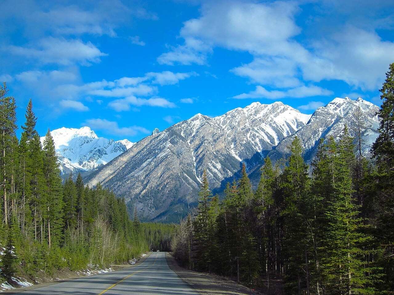
The stretch between Peyto Lake and the Columbia Icefield is the longest leg with the fewest named stops, and it is where the Parkway quietly does its best work. Saskatchewan Crossing sits roughly halfway — a small settlement with fuel (when open), a motel, and a restaurant — and the valleys north of it open up into the kind of wide, empty country that makes you stop the rig just to stand there. Wildlife lives here. I have seen black bears, elk, and bighorn sheep along this leg, and every one of them caused a small traffic jam of photographers. Pull fully off the road, stay in the rig if a bear is close, and never stop in a travel lane to take a photo. The animals are not a photo opportunity with a schedule.
Cell service comes and goes on this leg. Download your maps offline before Lake Louise, screenshot your Jasper accommodation address, and tell someone your rough plan. It is not the wilderness, exactly — it is a well-travelled highway — but it is the kind of road where a dead phone and a wrong turn cost you an hour, and I know because I have paid that hour.
4. Columbia Icefield & Athabasca Glacier — the big one
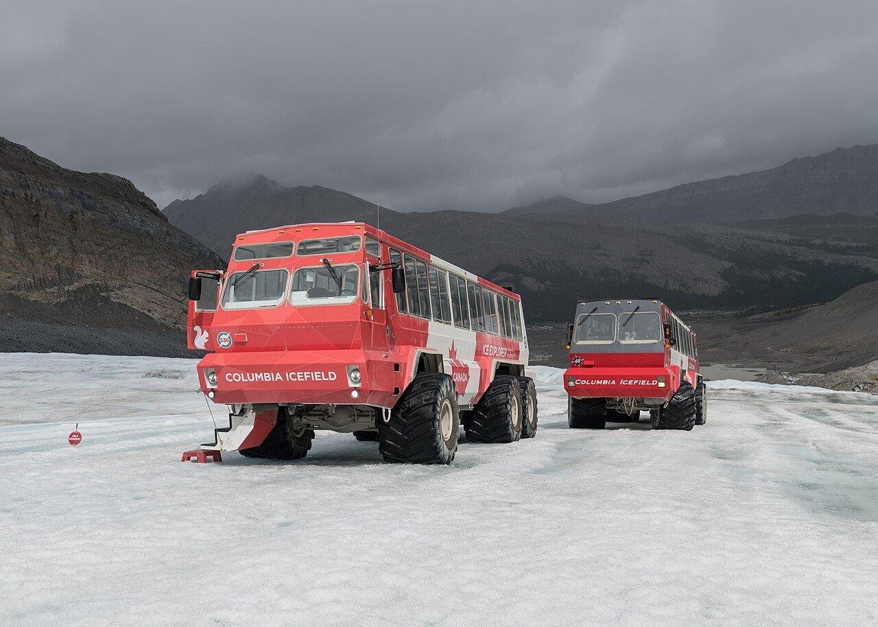
The Columbia Icefield is the largest icefield in the Rocky Mountains, and the Athabasca Glacier is the tongue of it you can actually stand on. The Ice Explorer — a giant-wheeled vehicle built for glacier ice — drives visitors from the Icefield Centre onto the glacier itself, and it is the single most memorable paid experience on the Parkway. I double-checked on Parks Canada’s page and the operator’s site before booking, because glacier access, tour times, and seasonal opening dates shift year to year — check the current season’s details before you count on a specific departure, and book ahead in July and August.
If you do not take the Ice Explorer, the free alternative is still strong: the toe-of-the-glacier trail from the Icefield Centre parking area walks you across the forefield to a viewpoint near the ice, and the interpretive signs explain how far the glacier has retreated in your lifetime. It is sobering, in a good way — the kind of walk that shuts a car full of chatty people up for a while. The Skywalk, a glass-floored platform over the Sunwapta Valley a few minutes’ drive from the Centre, is a separate ticket and a separate decision; go if heights do not bother you, skip it without guilt if they do.
The staff member who checked my Ice Explorer ticket told me the last departures of the day are the quietest — smaller groups, softer light on the ice, and fewer buses in the parking lot. I took the late slot on my second trip and had whole stretches of the glacier walk nearly to myself. Book late, not first thing, if your schedule allows it.
5. Sunwapta Falls — loud for its size

Sunwapta Falls is a short detour off the Parkway — a few hundred metres of trail from the parking area — and it punches above its height. The river squeezes through a narrow canyon and drops hard, and the sound hits you before the view does. Upper falls first, then the short trail down to the lower viewpoint if your knees are willing. Thirty minutes, in and out, and it breaks up the longest stretch of driving on the northern half beautifully.
Note the order here, because maps confuse people: driving north from the Icefield, Sunwapta Falls comes BEFORE Athabasca Falls. I have seen itineraries list them the other way around. They are wrong. Sunwapta first, Athabasca second, Jasper last.
6. Athabasca Falls — the crowd-pleaser

Athabasca Falls is not the tallest fall on this list, but it might be the most powerful-looking: the whole river forces itself through a narrow gap and drops 23 metres into a gorge it carved itself. The viewing platforms are close, the walkways are paved, and the whole stop takes half an hour. It is also the busiest waterfall stop on the Parkway, for obvious reasons — it is right off the road, ten minutes from a major junction, and every tour bus knows it.
Go early or late if you can, and do the short loop past the upper viewpoints rather than stopping at the first platform everyone crowds onto. The river here is a different animal in spring runoff versus late summer — May and June are thunderous, September is lower and clearer, and both are worth seeing. A ranger at the trailhead told me the gorge walls here are still being carved measurably in a human lifetime, which is a polite way of saying: respect the railings.
7. Jasper townsite — the finish line

Jasper is smaller, quieter, and less polished than Banff, and that is exactly why it works as the finish line. Park the rig, walk the main street, eat a real dinner, and sleep somewhere that is not a highway pullout. My where to stay in Jasper guide breaks down the townsite options by budget, and my Banff to Jasper road trip itinerary covers the wider loop if you are turning this leg into a longer Rockies trip. If you are heading back south the next day, Jasper is also where you fuel up properly — do not start the return leg on a hopeful gauge. I have made this mistake so you don’t have to.
One honest note about Jasper in 2026: the town and park are still recovering from the major 2024 wildfire season, and some trails, facilities, and services may still be affected. I checked the current conditions on Parks Canada’s Jasper page before my last trip, and you should too — conditions change as recovery work progresses, and a trail that was closed last season may be open now, or the reverse. The townsite itself is open and welcoming; just verify the specific hikes you want before you drive out to them. The same goes for smoke: summer wildfire smoke can flatten the views for days at a time across the Rockies, and no itinerary can promise you blue skies. Build a flexible day into a 2-day plan so a smoky morning costs you a viewpoint, not the trip.
1-day plan vs. 2-day plan
| Time | 1-day sprint (Lake Louise → Jasper) | 2-day relaxed |
|---|---|---|
| Morning | 7 AM: Lake Louise shoreline, fuel up, depart by 8 AM; Bow Lake 30 min; Peyto Lake 45 min | Day 1 AM: same start, slower — add the Bow Glacier Falls walk and a long Peyto stop |
| Midday | Drive to the Icefield; quick lunch at the Centre; Ice Explorer or glacier-toe walk | Day 1 PM: Icefield in full — Ice Explorer plus Skywalk; overnight at the Icefield area or Saskatchewan Crossing |
| Afternoon | Sunwapta Falls 30 min; Athabasca Falls 30 min; roll into Jasper by dinner | Day 2: slow morning, Sunwapta + Athabasca Falls, Parker Ridge or a valley hike if time allows, Jasper by late afternoon |
| Evening | Dinner + bed in Jasper; you earned it | Dinner in Jasper with zero rush — and a second shot at any viewpoint the weather stole on day 1 |
Which one? Here’s the deal: if you only have one day, the sprint works, but it works because you skip the hikes. If you can steal a second day, take it. The Parkway is not a road you “do” — it is a road you linger on, and the second day is where the lingering happens. My best time to visit the Canadian Rockies guide and best time to visit Banff guide will help you pick the month, and my where to stay in Banff guide covers the Lake Louise end if you are basing there first.
Pullouts worth the detour
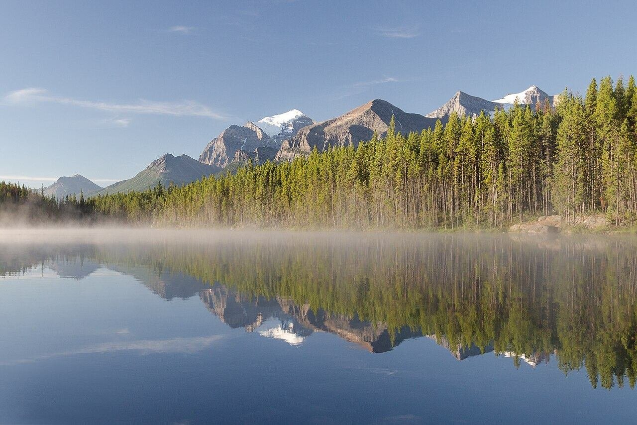
Beyond the seven named stops, three unsigned-or-underrated pullouts earned their place in my notes. Herbert Lake, minutes north of Lake Louise, is a still, small lake that mirrors the mountains on calm mornings — I stopped for five minutes and stayed twenty. Crowfoot Glacier viewpoint, just past Bow Lake, shows the glacier that used to look like a crow’s foot before it retreated; the interpretive sign there is quietly devastating and worth reading. And Parker Ridge, near the Icefield, is the one real hike worth adding on a 2-day plan: a steep but short climb to a ridge overlooking the Saskatchewan Glacier, about 2 to 3 hours return. A ranger at the trailhead told me to start Parker Ridge before 9 AM to beat both the heat and the crowds, and the ridge was nearly empty when I topped out.
Seasons: when the Parkway changes character
June through September is the straightforward season: all facilities open, all viewpoints accessible, all tour buses present. July and August are the busiest and the most expensive; June and September are my pick — fewer people, same scenery, cheaper beds. October through May is a different road: the Icefield Centre and most seasonal facilities close, avalanche risk closes or restricts sections, and winter tires are not a suggestion. The Parkway stays open in winter for through traffic when conditions allow, but it is a serious mountain highway in a storm, and Parks Canada may close sections with little notice. If you are driving it in winter, check road conditions the morning you leave, carry winter gear in the rig, and do not plan on stopping at viewpoints that are not plowed.
Winter driving on the Parkway is no joke: no services, no cell signal in long stretches, and storms that arrive over one ridge and sit on the next. I have driven mountain passes in winter and I still would not do this leg in a storm without winter tires, a full tank, food, water, and a charged phone. If the forecast turns, wait it out in Lake Louise or Jasper — the mountains will still be there tomorrow, and the road will be safer for it.
What does the Icefields Parkway cost?
Prices below are per person per day, including fuel share for a car shared by two people. Pick your travel style, tell the calculator how many days you’re staying, and it does the rest. Accommodation not included — see the table below for that.
Budget calculator
Per person, in Canadian dollars. Includes fuel. Excludes accommodation.
Budget ≈ $110/day · Mid-range ≈ $190/day · Luxury ≈ $315/day. Park pass and Ice Explorer ticket not included in the daily rate — see below.
| Expense (per person / day) | Budget | Mid-range | Luxury |
|---|---|---|---|
| Accommodation | $60 (hostel / basic motel) | $180 (Jasper hotel) | $350+ (lakeside lodge) |
| Food & drink | $40 | $65 | $110 |
| Sights (Ice Explorer, Skywalk) | $15 | $30 | $60 |
| Getting around (fuel share) | $45 | $75 | $110 |
| Coffee, treats & souvenirs | $10 | $20 | $35 |
| Daily total (excl. accommodation) | ~$110 | ~$190 | ~$315 |
On top of the daily rate, budget for the Parks Canada park pass (per vehicle, per day, or an annual Discovery Pass if you are doing a longer Rockies trip — I double-checked the current pass prices on Parks Canada’s page before my second drive) and the Ice Explorer ticket if you take it. For the wider trip budget, see my Canada trip cost guide, and if you are renting rather than bringing your own rig, my renting a car in Canada guide covers the one-way rental question.
FAQs about the Icefields Parkway itinerary
How long does it take to drive the Icefields Parkway?
Pure driving time is about 3 to 3.5 hours for the 232 km from Lake Louise to Jasper. With the stops in this guide, plan 6 to 8 hours for one day or a full two days if you want hikes and a slow Icefield visit. Anyone who tells you they “did it in three hours” drove past everything worth seeing.
Can you drive the Icefields Parkway in one day?
Yes — the 1-day plan above does exactly that, and it works if you start by 8 AM, keep stops tight, and pre-book the Ice Explorer. But two days is the better trip: you get the hikes, the late-afternoon light at the Icefield, and a spare morning if weather steals a viewpoint. If one day is all you have, do not add extra detours; the seven stops here already fill it.
Where can you get gas on the Icefields Parkway?
Fuel up in Lake Louise before you leave, and again in Jasper when you arrive. The only mid-route option is Saskatchewan Crossing (roughly halfway), plus seasonal fuel near the Columbia Icefield area — and neither should be counted on outside summer or late in the day. There is no gas station on the Parkway itself. I have made this mistake so you don’t have to: leave Lake Louise on a full tank.
What is the best time of year to drive the Icefields Parkway?
June through September for the full experience: all facilities open, all viewpoints accessible, and the Ice Explorer running. I prefer June and September — fewer crowds, lower prices, same scenery. October through May brings closures, winter driving conditions, and seasonal facilities shut — the road can still be driven in winter when open, but it is a serious mountain highway, not a sightseeing cruise. See my best time to visit the Canadian Rockies guide for the month-by-month picture.
Do you need a park pass for the Icefields Parkway?
Yes. The Parkway runs through Banff and Jasper national parks, so you need a valid Parks Canada park pass for the vehicle. A daily pass covers the day; a Discovery Pass (annual) pays off if you are spending several days in the parks. I double-checked the current pass options on Parks Canada’s page before my last trip — check before you go, since prices and purchase points change. → Parks Canada — official site
Is the Icefields Parkway drive safe, and what about wildlife?
It is a well-maintained two-lane mountain highway with a 90 km/h limit in most sections, but it demands respect: wildlife on the road, sudden weather, long gaps without services or cell signal, and winter conditions for much of the year. Slow down for every animal warning sign — the bear jam I sat in near the Icefield was caused by a grizzly twenty metres off the road, and nobody regretted slowing down. Stay in your vehicle near bears and elk, never feed wildlife, and keep a proper distance. The drive is safe if you drive it like a mountain road, not a freeway.
Keep exploring
The Parkway is one leg of a bigger Rockies trip — here’s where I’d go next:
- Banff to Jasper road trip itinerary — the wider loop this leg sits inside
- Where to stay in Jasper — townsite beds by budget
- Where to stay in Banff — the Lake Louise end, sorted
- Best time to visit Banff — picking your month
- Best time to visit the Canadian Rockies — the full seasonal picture
- Canada trip cost guide — budgeting the wider trip
- Renting a car in Canada — rig, insurance, and one-way questions
Buckle up. Gas up. The Parkway will do the rest.
4 comments